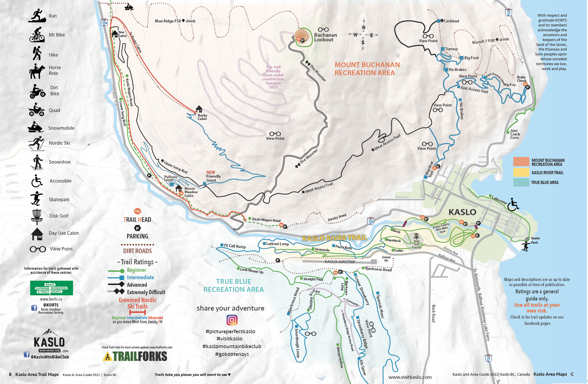
In the brand new Visit Kaslo & Area Guide you will find a pull out map of Kaslo, the area trail network, and all the smaller communities in our area. Trails to hike and mountain bike are made and maintained by the KORTS – Kaslo Outdoor Recreation and Trails Society Kaslo & District Community Forest, Kaslo to Sandon Rails to Trails Society, and many volunteers.
Trail tips:
Kaslo River Trail:
- To walk to the famous beet Red Covered Bridge, take the Kaslo River Trail, then keep going all the way around. It’s beautiful!
- To run a long distance on forested trails, take the Kaslo River Trail and keep to your right after crossing the bridge (turning left will take you back to town.) The Lettrari Loop (aka Southern River Extension) winds along the south side of the Kaslo River, eventually rising up to where the transfer station is at the west end of the airport lands. You can continue running east on the sawdust strewn paths alongside the airstrip and then duck down to rejoin the lower river trails.
- Access: North access from town side: take Fifth Street which turns into Railway. Behind Public Works Yard: cross the Hwy 31 (4th Street) bridge, turn right on Spruce Street, look for the Trailhead sign. Parking is available.
True Blue Recreation Area
There is a lot of variety on the multi-purpose trails above the airport in the True Blue Recreation Area, with about 9 trails of various difficulty. Spanish Moss (trail 9) is one of our favourites to walk or mountain bike!!
Access: Take Hwy 31 heading south out of Kaslo, turn right on Balfour Ave. (before the Esso), follow Balfour Ave up the hill until you reach the gravel pit on the left before the airport. Look for sign on left for True Blue Recreation Trails, turn left into road at gravel pit.
Wardner Trail
For a steep climb to a great lookout over Kaslo and Kootenay Lake, check out the Wardner Trail. Access the trail off Wardner Street in upper Kaslo.

Mount Buchanan
Cycle or get shuttled to the top of Mount Buchanan for a stunning view of the valleys and Kootenay Lake.
Then take the famous and extreme, 5 star rated downhill trail “The Monster” and drop 4000 vertical feet back down to the valley bottom. Ride at your own risk. No guarantee of trail condition.
Access Mount Buchanan from Kaslo, head west on highway #31A for 11 km to the Blue Ridge Forest Services Road, then follow signs. Follow the main road for 11.9 km to the lookout, staying right at the 7.0 km junction. 4×4 recommended.
Wagon Road Trail
The Wagon Road Trail is a nice multi-purpose trail that can get you right to Fish and Bear Lake. It is great for cross-country skiing in the winter!
Access the head of the Historic Wagon Trail by driving nearly to the end of Victoria Ave which turns into Zwicky Road, in upper Kaslo. Limited signed parking, then a short walk to trail head.
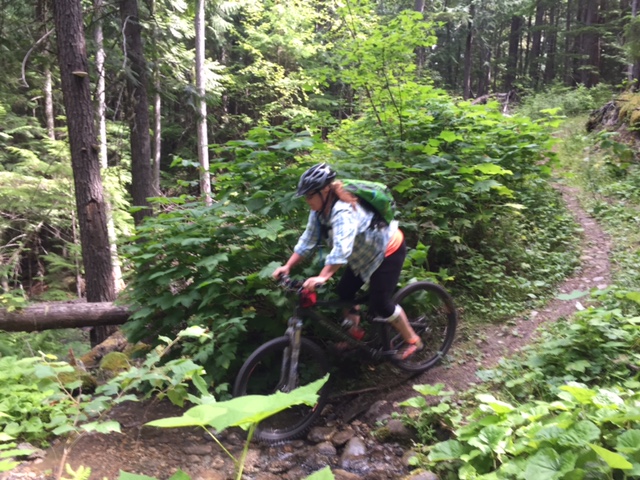
A great way to stay healthy is to hike and mountain bike, and the Kaslo area has trails in abundance.
Back-country Hiking/Biking – Trail info and map links
For map to the Buchanan Recreation Area visit Kaslo Community Forest’s website: http://www.kaslocommunityforest.org/recreation
Kaslo Outdoor Recreation Society: http://korsbc.blogspot.ca/p/about-us.html
*All trails can be found at https://www.trailforks.com/
See where to eat, sleep, play and shop in town. Also, visit www.gokootenays.com to learn more about the surrounding Kootenay areas.

