LnRiLWZpZWxke21hcmdpbi1ib3R0b206MC43NmVtfS50Yi1maWVsZC0tbGVmdHt0ZXh0LWFsaWduOmxlZnR9LnRiLWZpZWxkLS1jZW50ZXJ7dGV4dC1hbGlnbjpjZW50ZXJ9LnRiLWZpZWxkLS1yaWdodHt0ZXh0LWFsaWduOnJpZ2h0fS50Yi1maWVsZF9fc2t5cGVfcHJldmlld3twYWRkaW5nOjEwcHggMjBweDtib3JkZXItcmFkaXVzOjNweDtjb2xvcjojZmZmO2JhY2tncm91bmQ6IzAwYWZlZTtkaXNwbGF5OmlubGluZS1ibG9ja311bC5nbGlkZV9fc2xpZGVze21hcmdpbjowfQ==
LnRiLWltYWdlLnRiLWltYWdlLWZyYW1lLXNoYWRvdzEgZmlnY2FwdGlvbnttYXJnaW4tdG9wOjB9LnRiLWltYWdlIC50Yi1pbWFnZS1zaGFkb3ctMXtkaXNwbGF5OmlubGluZS1ibG9jaztwb3NpdGlvbjpyZWxhdGl2ZTt0cmFuc2l0aW9uOnRyYW5zZm9ybSAwLjI1cyBlYXNlfS50Yi1pbWFnZSAudGItaW1hZ2Utc2hhZG93LTEtc2hhZG93cy1jb250YWluZXJ7cG9zaXRpb246cmVsYXRpdmV9LnRiLWltYWdlIC50Yi1pbWFnZS1zaGFkb3ctMS1pbm5lcntvdmVyZmxvdzpoaWRkZW47cG9zaXRpb246cmVsYXRpdmU7ei1pbmRleDoyO2JhY2tncm91bmQtY29sb3I6I2ZmZn0udGItaW1hZ2UgLnRiLWltYWdlLXNoYWRvdy0xLWlubmVyIGltZ3tkaXNwbGF5OmJsb2NrO3dpZHRoOjEwMCV9LnRiLWltYWdlIC50Yi1pbWFnZS1zaGFkb3ctMS1zaGFkb3ctMSwudGItaW1hZ2UgLnRiLWltYWdlLXNoYWRvdy0xLXNoYWRvdy0ye3Bvc2l0aW9uOmFic29sdXRlO3otaW5kZXg6MTtib3R0b206MTVweDtsZWZ0OjEwcHg7d2lkdGg6NTAlO3RvcDo4MCU7bWF4LXdpZHRoOjMwMHB4O2JhY2tncm91bmQ6Izc3Nztib3gtc2hhZG93OjAgMTVweCAxMHB4ICM3Nzc7dHJhbnNmb3JtOnJvdGF0ZSgtM2RlZyl9LnRiLWltYWdlIC50Yi1pbWFnZS1zaGFkb3ctMS1zaGFkb3ctMnt0cmFuc2Zvcm06cm90YXRlKDNkZWcpO3JpZ2h0OjEwcHg7bGVmdDphdXRvfQ==
QWN0b3I6cmVndWxhcg==
LnRiLWZpZWxkW2RhdGEtdG9vbHNldC1ibG9ja3MtZmllbGQ9IjQ1OTA0ZWVlMTZmZjMxYzEzYTk0YWFmOWRlMmI0OWY1Il0geyBmb250LXNpemU6IDE4cHg7Zm9udC13ZWlnaHQ6IGJvbGQ7dGV4dC1hbGlnbjogY2VudGVyO2NvbG9yOiByZ2JhKCA2MywgNjMsIDYzLCAxICk7cGFkZGluZy10b3A6IDZweDtwYWRkaW5nLWJvdHRvbTogOXB4O21hcmdpbi10b3A6IC0xMXB4O2JvcmRlci10b3A6IDFweCBzb2xpZCByZ2JhKCAyMjIsIDIyMSwgMjIxLCAxICk7IH0gIC50Yi1maWVsZFtkYXRhLXRvb2xzZXQtYmxvY2tzLWZpZWxkPSJkNTVhZTJlYmIyYjdlNWMyYWQ4M2U3YzMxMWRjN2YzYyJdIHsgZm9udC13ZWlnaHQ6IG5vcm1hbDt0ZXh0LWFsaWduOiBsZWZ0OyB9ICAudGItZmllbGRbZGF0YS10b29sc2V0LWJsb2Nrcy1maWVsZD0iNDI2NGMzY2IzNjI4ZTljOGYzNDhkOGJjN2ZmMWI1OGYiXSB7IGZvbnQtd2VpZ2h0OiBub3JtYWw7bGV0dGVyLXNwYWNpbmc6IDBweDt0ZXh0LWFsaWduOiByaWdodDtjb2xvcjogcmdiYSggNzUsIDc5LCA4OCwgMSApO3BhZGRpbmctcmlnaHQ6IDExcHg7bWFyZ2luLXJpZ2h0OiAtMTJweDtib3JkZXItcmlnaHQ6IDFweCBzb2xpZCByZ2JhKCAwLCAwLCAwLCAwLjI2ICk7IH0gIC50Yi1maWVsZHMtYW5kLXRleHRbZGF0YS10b29sc2V0LWJsb2Nrcy1maWVsZHMtYW5kLXRleHQ9ImMzYTA1NTk4ZGIyYzJkYTlmMWM2NzUwZDA5ZTZlYjQ2Il0geyBmb250LXNpemU6IDExcHg7Zm9udC1zdHlsZTogaXRhbGljO2xpbmUtaGVpZ2h0OiAxM3B4O2NvbG9yOiByZ2JhKCAxMzUsIDEzNSwgMTM1LCAxICk7cGFkZGluZy1ib3R0b206IDdweDsgfSAudGItZmllbGRzLWFuZC10ZXh0W2RhdGEtdG9vbHNldC1ibG9ja3MtZmllbGRzLWFuZC10ZXh0PSJjM2EwNTU5OGRiMmMyZGE5ZjFjNjc1MGQwOWU2ZWI0NiJdIHAgeyBmb250LXNpemU6IDExcHg7Zm9udC1zdHlsZTogaXRhbGljO2xpbmUtaGVpZ2h0OiAxM3B4O2NvbG9yOiByZ2JhKCAxMzUsIDEzNSwgMTM1LCAxICk7IH0gLnRiLWZpZWxkW2RhdGEtdG9vbHNldC1ibG9ja3MtZmllbGQ9ImQxZWI3M2M1ZmJjOTY0NmUzOWU1OTNhMGU5MjUwMTQ4Il0geyBmb250LXNpemU6IDIwcHg7Zm9udC1mYW1pbHk6IEFjdG9yO2ZvbnQtd2VpZ2h0OiBib2xkO3RleHQtYWxpZ246IGNlbnRlcjtjb2xvcjogcmdiYSggNjMsIDYzLCA2MywgMSApO3BhZGRpbmctdG9wOiA5cHg7Ym9yZGVyLXRvcDogMHB4IHNvbGlkIHJnYmEoIDI0MSwgMjQxLCAyNDEsIDEgKTsgfSAgLnRiLWltYWdle3Bvc2l0aW9uOnJlbGF0aXZlO3RyYW5zaXRpb246dHJhbnNmb3JtIDAuMjVzIGVhc2V9LndwLWJsb2NrLWltYWdlIC50Yi1pbWFnZS5hbGlnbmNlbnRlcnttYXJnaW4tbGVmdDphdXRvO21hcmdpbi1yaWdodDphdXRvfS50Yi1pbWFnZSBpbWd7bWF4LXdpZHRoOjEwMCU7aGVpZ2h0OmF1dG87d2lkdGg6YXV0bzt0cmFuc2l0aW9uOnRyYW5zZm9ybSAwLjI1cyBlYXNlfS50Yi1pbWFnZSAudGItaW1hZ2UtY2FwdGlvbi1maXQtdG8taW1hZ2V7ZGlzcGxheTp0YWJsZX0udGItaW1hZ2UgLnRiLWltYWdlLWNhcHRpb24tZml0LXRvLWltYWdlIC50Yi1pbWFnZS1jYXB0aW9ue2Rpc3BsYXk6dGFibGUtY2FwdGlvbjtjYXB0aW9uLXNpZGU6Ym90dG9tfSAudGItaW1hZ2VbZGF0YS10b29sc2V0LWJsb2Nrcy1pbWFnZT0iMGY0MzMyNGFhYjUwNTQ2YjcyMzQxNzdlNTQyYzBiMjQiXSB7IG1heC13aWR0aDogMTAwJTt0cmFuc2Zvcm06IHJvdGF0ZSgwZGVnKTsgfSAudGItaW1hZ2VbZGF0YS10b29sc2V0LWJsb2Nrcy1pbWFnZT0iMGY0MzMyNGFhYjUwNTQ2YjcyMzQxNzdlNTQyYzBiMjQiXSAudGItaW1hZ2Utc2hhZG93LTEtaW5uZXIgeyBib3JkZXI6IDBweCBzb2xpZCByZ2JhKCAwLCAwLCAwLCAwLjI1ICk7IH0gLnRiLWNvbnRhaW5lciAudGItY29udGFpbmVyLWlubmVye3dpZHRoOjEwMCU7bWFyZ2luOjAgYXV0b30gLndwLWJsb2NrLXRvb2xzZXQtYmxvY2tzLWNvbnRhaW5lci50Yi1jb250YWluZXJbZGF0YS10b29sc2V0LWJsb2Nrcy1jb250YWluZXI9IjdmMzc4NGMxYTY5NTMzYTQ2NjJjZjdlMjI3OWNiM2NjIl0geyBwYWRkaW5nOiAyNXB4O2JvcmRlci10b3A6IDFweCBzb2xpZCByZ2JhKCAwLCAwLCAwLCAxICk7IH0gLnRiLWdyaWQsLnRiLWdyaWQ+LmJsb2NrLWVkaXRvci1pbm5lci1ibG9ja3M+LmJsb2NrLWVkaXRvci1ibG9jay1saXN0X19sYXlvdXR7ZGlzcGxheTpncmlkO2dyaWQtcm93LWdhcDoyNXB4O2dyaWQtY29sdW1uLWdhcDoyNXB4fS50Yi1ncmlkLWl0ZW17YmFja2dyb3VuZDojZDM4YTAzO3BhZGRpbmc6MzBweH0udGItZ3JpZC1jb2x1bW57ZmxleC13cmFwOndyYXB9LnRiLWdyaWQtY29sdW1uPip7d2lkdGg6MTAwJX0udGItZ3JpZC1jb2x1bW4udGItZ3JpZC1hbGlnbi10b3B7d2lkdGg6MTAwJTtkaXNwbGF5OmZsZXg7YWxpZ24tY29udGVudDpmbGV4LXN0YXJ0fS50Yi1ncmlkLWNvbHVtbi50Yi1ncmlkLWFsaWduLWNlbnRlcnt3aWR0aDoxMDAlO2Rpc3BsYXk6ZmxleDthbGlnbi1jb250ZW50OmNlbnRlcn0udGItZ3JpZC1jb2x1bW4udGItZ3JpZC1hbGlnbi1ib3R0b217d2lkdGg6MTAwJTtkaXNwbGF5OmZsZXg7YWxpZ24tY29udGVudDpmbGV4LWVuZH0udGItZmllbGRzLWFuZC10ZXh0W2RhdGEtdG9vbHNldC1ibG9ja3MtZmllbGRzLWFuZC10ZXh0PSJkYzQxMTFmYjVkNDUyNzEwZGFhMzJjMTY0OWQzYzQzOCJdIHsgZm9udC13ZWlnaHQ6IG5vcm1hbDsgfSAudGItZmllbGRzLWFuZC10ZXh0W2RhdGEtdG9vbHNldC1ibG9ja3MtZmllbGRzLWFuZC10ZXh0PSJkYzQxMTFmYjVkNDUyNzEwZGFhMzJjMTY0OWQzYzQzOCJdIHAgeyBmb250LXdlaWdodDogbm9ybWFsOyB9IC50Yi1jb250YWluZXIgLnRiLWNvbnRhaW5lci1pbm5lcnt3aWR0aDoxMDAlO21hcmdpbjowIGF1dG99IC53cC1ibG9jay10b29sc2V0LWJsb2Nrcy1jb250YWluZXIudGItY29udGFpbmVyW2RhdGEtdG9vbHNldC1ibG9ja3MtY29udGFpbmVyPSIzNGJiODUzMzZkZWYzOTA4ZmU1MTM0NDRkMDVlY2VmNiJdIHsgcGFkZGluZzogMjVweCAwcHggMjVweCAwcHg7ZGlzcGxheTptcy1mbGV4Ym94ICFpbXBvcnRhbnQ7ZGlzcGxheTpmbGV4ICFpbXBvcnRhbnQ7LW1zLWZsZXgtZGlyZWN0aW9uOmNvbHVtbjtmbGV4LWRpcmVjdGlvbjpjb2x1bW47LW1zLWZsZXgtcGFjazpjZW50ZXI7anVzdGlmeS1jb250ZW50OmNlbnRlcjsgfSAudGItZ3JpZCwudGItZ3JpZD4uYmxvY2stZWRpdG9yLWlubmVyLWJsb2Nrcz4uYmxvY2stZWRpdG9yLWJsb2NrLWxpc3RfX2xheW91dHtkaXNwbGF5OmdyaWQ7Z3JpZC1yb3ctZ2FwOjI1cHg7Z3JpZC1jb2x1bW4tZ2FwOjI1cHh9LnRiLWdyaWQtaXRlbXtiYWNrZ3JvdW5kOiNkMzhhMDM7cGFkZGluZzozMHB4fS50Yi1ncmlkLWNvbHVtbntmbGV4LXdyYXA6d3JhcH0udGItZ3JpZC1jb2x1bW4+Knt3aWR0aDoxMDAlfS50Yi1ncmlkLWNvbHVtbi50Yi1ncmlkLWFsaWduLXRvcHt3aWR0aDoxMDAlO2Rpc3BsYXk6ZmxleDthbGlnbi1jb250ZW50OmZsZXgtc3RhcnR9LnRiLWdyaWQtY29sdW1uLnRiLWdyaWQtYWxpZ24tY2VudGVye3dpZHRoOjEwMCU7ZGlzcGxheTpmbGV4O2FsaWduLWNvbnRlbnQ6Y2VudGVyfS50Yi1ncmlkLWNvbHVtbi50Yi1ncmlkLWFsaWduLWJvdHRvbXt3aWR0aDoxMDAlO2Rpc3BsYXk6ZmxleDthbGlnbi1jb250ZW50OmZsZXgtZW5kfSAud3B2LXZpZXctb3V0cHV0W2RhdGEtdG9vbHNldC12aWV3cy12aWV3LWVkaXRvcj0iMzY2NmY1OTQ1ZTA2YzZlNDIzNzI0MzM2MTYzMjViNjciXSA+IC50Yi1ncmlkLWNvbHVtbjpudGgtb2YtdHlwZSgzbiArIDEpIHsgZ3JpZC1jb2x1bW46IDEgfSAud3B2LXZpZXctb3V0cHV0W2RhdGEtdG9vbHNldC12aWV3cy12aWV3LWVkaXRvcj0iMzY2NmY1OTQ1ZTA2YzZlNDIzNzI0MzM2MTYzMjViNjciXSA+IC50Yi1ncmlkLWNvbHVtbjpudGgtb2YtdHlwZSgzbiArIDIpIHsgZ3JpZC1jb2x1bW46IDIgfSAud3B2LXZpZXctb3V0cHV0W2RhdGEtdG9vbHNldC12aWV3cy12aWV3LWVkaXRvcj0iMzY2NmY1OTQ1ZTA2YzZlNDIzNzI0MzM2MTYzMjViNjciXSA+IC50Yi1ncmlkLWNvbHVtbjpudGgtb2YtdHlwZSgzbiArIDMpIHsgZ3JpZC1jb2x1bW46IDMgfSAud3B2LXZpZXctb3V0cHV0W2RhdGEtdG9vbHNldC12aWV3cy12aWV3LWVkaXRvcj0iMzY2NmY1OTQ1ZTA2YzZlNDIzNzI0MzM2MTYzMjViNjciXSAuanMtd3B2LWxvb3Atd3JhcHBlciA+IC50Yi1ncmlkIHsgZ3JpZC10ZW1wbGF0ZS1jb2x1bW5zOiBtaW5tYXgoMCwgMC4zMzMzZnIpIG1pbm1heCgwLCAwLjMzMzNmcikgbWlubWF4KDAsIDAuMzMzM2ZyKTtncmlkLWF1dG8tZmxvdzogcm93IH0gLndwdi1ibG9jay1sb29wLWl0ZW1bZGF0YS10b29sc2V0LXZpZXdzLXZpZXctdGVtcGxhdGUtYmxvY2s9ImI1ODQ4MWZlN2UwNTEzNWJhN2U1OWEzZmM5YzRjNWY0Il0geyBmb250LXNpemU6IDExcHg7bGluZS1oZWlnaHQ6IDE2cHg7YmFja2dyb3VuZC1jb2xvcjogcmdiYSggMjU1LCAyNTUsIDI1NSwgMSApO3BhZGRpbmctdG9wOiA5cHg7cGFkZGluZy1yaWdodDogOXB4O3BhZGRpbmctbGVmdDogOXB4O2JvcmRlci1yYWRpdXM6IDlweDtib3gtc2hhZG93OiAwIDAgNHB4IDAgcmdiYSggMCwgMCwgMCwgMC41ICk7IH0gQG1lZGlhIG9ubHkgc2NyZWVuIGFuZCAobWF4LXdpZHRoOiA3ODFweCkgeyAgICAgLnRiLWltYWdle3Bvc2l0aW9uOnJlbGF0aXZlO3RyYW5zaXRpb246dHJhbnNmb3JtIDAuMjVzIGVhc2V9LndwLWJsb2NrLWltYWdlIC50Yi1pbWFnZS5hbGlnbmNlbnRlcnttYXJnaW4tbGVmdDphdXRvO21hcmdpbi1yaWdodDphdXRvfS50Yi1pbWFnZSBpbWd7bWF4LXdpZHRoOjEwMCU7aGVpZ2h0OmF1dG87d2lkdGg6YXV0bzt0cmFuc2l0aW9uOnRyYW5zZm9ybSAwLjI1cyBlYXNlfS50Yi1pbWFnZSAudGItaW1hZ2UtY2FwdGlvbi1maXQtdG8taW1hZ2V7ZGlzcGxheTp0YWJsZX0udGItaW1hZ2UgLnRiLWltYWdlLWNhcHRpb24tZml0LXRvLWltYWdlIC50Yi1pbWFnZS1jYXB0aW9ue2Rpc3BsYXk6dGFibGUtY2FwdGlvbjtjYXB0aW9uLXNpZGU6Ym90dG9tfS50Yi1jb250YWluZXIgLnRiLWNvbnRhaW5lci1pbm5lcnt3aWR0aDoxMDAlO21hcmdpbjowIGF1dG99LnRiLWdyaWQsLnRiLWdyaWQ+LmJsb2NrLWVkaXRvci1pbm5lci1ibG9ja3M+LmJsb2NrLWVkaXRvci1ibG9jay1saXN0X19sYXlvdXR7ZGlzcGxheTpncmlkO2dyaWQtcm93LWdhcDoyNXB4O2dyaWQtY29sdW1uLWdhcDoyNXB4fS50Yi1ncmlkLWl0ZW17YmFja2dyb3VuZDojZDM4YTAzO3BhZGRpbmc6MzBweH0udGItZ3JpZC1jb2x1bW57ZmxleC13cmFwOndyYXB9LnRiLWdyaWQtY29sdW1uPip7d2lkdGg6MTAwJX0udGItZ3JpZC1jb2x1bW4udGItZ3JpZC1hbGlnbi10b3B7d2lkdGg6MTAwJTtkaXNwbGF5OmZsZXg7YWxpZ24tY29udGVudDpmbGV4LXN0YXJ0fS50Yi1ncmlkLWNvbHVtbi50Yi1ncmlkLWFsaWduLWNlbnRlcnt3aWR0aDoxMDAlO2Rpc3BsYXk6ZmxleDthbGlnbi1jb250ZW50OmNlbnRlcn0udGItZ3JpZC1jb2x1bW4udGItZ3JpZC1hbGlnbi1ib3R0b217d2lkdGg6MTAwJTtkaXNwbGF5OmZsZXg7YWxpZ24tY29udGVudDpmbGV4LWVuZH0udGItY29udGFpbmVyIC50Yi1jb250YWluZXItaW5uZXJ7d2lkdGg6MTAwJTttYXJnaW46MCBhdXRvfS50Yi1ncmlkLC50Yi1ncmlkPi5ibG9jay1lZGl0b3ItaW5uZXItYmxvY2tzPi5ibG9jay1lZGl0b3ItYmxvY2stbGlzdF9fbGF5b3V0e2Rpc3BsYXk6Z3JpZDtncmlkLXJvdy1nYXA6MjVweDtncmlkLWNvbHVtbi1nYXA6MjVweH0udGItZ3JpZC1pdGVte2JhY2tncm91bmQ6I2QzOGEwMztwYWRkaW5nOjMwcHh9LnRiLWdyaWQtY29sdW1ue2ZsZXgtd3JhcDp3cmFwfS50Yi1ncmlkLWNvbHVtbj4qe3dpZHRoOjEwMCV9LnRiLWdyaWQtY29sdW1uLnRiLWdyaWQtYWxpZ24tdG9we3dpZHRoOjEwMCU7ZGlzcGxheTpmbGV4O2FsaWduLWNvbnRlbnQ6ZmxleC1zdGFydH0udGItZ3JpZC1jb2x1bW4udGItZ3JpZC1hbGlnbi1jZW50ZXJ7d2lkdGg6MTAwJTtkaXNwbGF5OmZsZXg7YWxpZ24tY29udGVudDpjZW50ZXJ9LnRiLWdyaWQtY29sdW1uLnRiLWdyaWQtYWxpZ24tYm90dG9te3dpZHRoOjEwMCU7ZGlzcGxheTpmbGV4O2FsaWduLWNvbnRlbnQ6ZmxleC1lbmR9IC53cHYtdmlldy1vdXRwdXRbZGF0YS10b29sc2V0LXZpZXdzLXZpZXctZWRpdG9yPSIzNjY2ZjU5NDVlMDZjNmU0MjM3MjQzMzYxNjMyNWI2NyJdID4gLnRiLWdyaWQtY29sdW1uOm50aC1vZi10eXBlKDNuICsgMSkgeyBncmlkLWNvbHVtbjogMSB9IC53cHYtdmlldy1vdXRwdXRbZGF0YS10b29sc2V0LXZpZXdzLXZpZXctZWRpdG9yPSIzNjY2ZjU5NDVlMDZjNmU0MjM3MjQzMzYxNjMyNWI2NyJdID4gLnRiLWdyaWQtY29sdW1uOm50aC1vZi10eXBlKDNuICsgMikgeyBncmlkLWNvbHVtbjogMiB9IC53cHYtdmlldy1vdXRwdXRbZGF0YS10b29sc2V0LXZpZXdzLXZpZXctZWRpdG9yPSIzNjY2ZjU5NDVlMDZjNmU0MjM3MjQzMzYxNjMyNWI2NyJdID4gLnRiLWdyaWQtY29sdW1uOm50aC1vZi10eXBlKDNuICsgMykgeyBncmlkLWNvbHVtbjogMyB9IC53cHYtdmlldy1vdXRwdXRbZGF0YS10b29sc2V0LXZpZXdzLXZpZXctZWRpdG9yPSIzNjY2ZjU5NDVlMDZjNmU0MjM3MjQzMzYxNjMyNWI2NyJdIC5qcy13cHYtbG9vcC13cmFwcGVyID4gLnRiLWdyaWQgeyBncmlkLXRlbXBsYXRlLWNvbHVtbnM6IG1pbm1heCgwLCAwLjMzMzNmcikgbWlubWF4KDAsIDAuMzMzM2ZyKSBtaW5tYXgoMCwgMC4zMzMzZnIpO2dyaWQtYXV0by1mbG93OiByb3cgfSAgfSBAbWVkaWEgb25seSBzY3JlZW4gYW5kIChtYXgtd2lkdGg6IDU5OXB4KSB7ICAgICAudGItaW1hZ2V7cG9zaXRpb246cmVsYXRpdmU7dHJhbnNpdGlvbjp0cmFuc2Zvcm0gMC4yNXMgZWFzZX0ud3AtYmxvY2staW1hZ2UgLnRiLWltYWdlLmFsaWduY2VudGVye21hcmdpbi1sZWZ0OmF1dG87bWFyZ2luLXJpZ2h0OmF1dG99LnRiLWltYWdlIGltZ3ttYXgtd2lkdGg6MTAwJTtoZWlnaHQ6YXV0bzt3aWR0aDphdXRvO3RyYW5zaXRpb246dHJhbnNmb3JtIDAuMjVzIGVhc2V9LnRiLWltYWdlIC50Yi1pbWFnZS1jYXB0aW9uLWZpdC10by1pbWFnZXtkaXNwbGF5OnRhYmxlfS50Yi1pbWFnZSAudGItaW1hZ2UtY2FwdGlvbi1maXQtdG8taW1hZ2UgLnRiLWltYWdlLWNhcHRpb257ZGlzcGxheTp0YWJsZS1jYXB0aW9uO2NhcHRpb24tc2lkZTpib3R0b219LnRiLWNvbnRhaW5lciAudGItY29udGFpbmVyLWlubmVye3dpZHRoOjEwMCU7bWFyZ2luOjAgYXV0b30udGItZ3JpZCwudGItZ3JpZD4uYmxvY2stZWRpdG9yLWlubmVyLWJsb2Nrcz4uYmxvY2stZWRpdG9yLWJsb2NrLWxpc3RfX2xheW91dHtkaXNwbGF5OmdyaWQ7Z3JpZC1yb3ctZ2FwOjI1cHg7Z3JpZC1jb2x1bW4tZ2FwOjI1cHh9LnRiLWdyaWQtaXRlbXtiYWNrZ3JvdW5kOiNkMzhhMDM7cGFkZGluZzozMHB4fS50Yi1ncmlkLWNvbHVtbntmbGV4LXdyYXA6d3JhcH0udGItZ3JpZC1jb2x1bW4+Knt3aWR0aDoxMDAlfS50Yi1ncmlkLWNvbHVtbi50Yi1ncmlkLWFsaWduLXRvcHt3aWR0aDoxMDAlO2Rpc3BsYXk6ZmxleDthbGlnbi1jb250ZW50OmZsZXgtc3RhcnR9LnRiLWdyaWQtY29sdW1uLnRiLWdyaWQtYWxpZ24tY2VudGVye3dpZHRoOjEwMCU7ZGlzcGxheTpmbGV4O2FsaWduLWNvbnRlbnQ6Y2VudGVyfS50Yi1ncmlkLWNvbHVtbi50Yi1ncmlkLWFsaWduLWJvdHRvbXt3aWR0aDoxMDAlO2Rpc3BsYXk6ZmxleDthbGlnbi1jb250ZW50OmZsZXgtZW5kfS50Yi1jb250YWluZXIgLnRiLWNvbnRhaW5lci1pbm5lcnt3aWR0aDoxMDAlO21hcmdpbjowIGF1dG99LnRiLWdyaWQsLnRiLWdyaWQ+LmJsb2NrLWVkaXRvci1pbm5lci1ibG9ja3M+LmJsb2NrLWVkaXRvci1ibG9jay1saXN0X19sYXlvdXR7ZGlzcGxheTpncmlkO2dyaWQtcm93LWdhcDoyNXB4O2dyaWQtY29sdW1uLWdhcDoyNXB4fS50Yi1ncmlkLWl0ZW17YmFja2dyb3VuZDojZDM4YTAzO3BhZGRpbmc6MzBweH0udGItZ3JpZC1jb2x1bW57ZmxleC13cmFwOndyYXB9LnRiLWdyaWQtY29sdW1uPip7d2lkdGg6MTAwJX0udGItZ3JpZC1jb2x1bW4udGItZ3JpZC1hbGlnbi10b3B7d2lkdGg6MTAwJTtkaXNwbGF5OmZsZXg7YWxpZ24tY29udGVudDpmbGV4LXN0YXJ0fS50Yi1ncmlkLWNvbHVtbi50Yi1ncmlkLWFsaWduLWNlbnRlcnt3aWR0aDoxMDAlO2Rpc3BsYXk6ZmxleDthbGlnbi1jb250ZW50OmNlbnRlcn0udGItZ3JpZC1jb2x1bW4udGItZ3JpZC1hbGlnbi1ib3R0b217d2lkdGg6MTAwJTtkaXNwbGF5OmZsZXg7YWxpZ24tY29udGVudDpmbGV4LWVuZH0gLndwdi12aWV3LW91dHB1dFtkYXRhLXRvb2xzZXQtdmlld3Mtdmlldy1lZGl0b3I9IjM2NjZmNTk0NWUwNmM2ZTQyMzcyNDMzNjE2MzI1YjY3Il0gID4gLnRiLWdyaWQtY29sdW1uOm50aC1vZi10eXBlKDFuKzEpIHsgZ3JpZC1jb2x1bW46IDEgfSAud3B2LXZpZXctb3V0cHV0W2RhdGEtdG9vbHNldC12aWV3cy12aWV3LWVkaXRvcj0iMzY2NmY1OTQ1ZTA2YzZlNDIzNzI0MzM2MTYzMjViNjciXSAuanMtd3B2LWxvb3Atd3JhcHBlciA+IC50Yi1ncmlkIHsgZ3JpZC10ZW1wbGF0ZS1jb2x1bW5zOiBtaW5tYXgoMCwgMWZyKTtncmlkLWF1dG8tZmxvdzogcm93IH0gIH0g
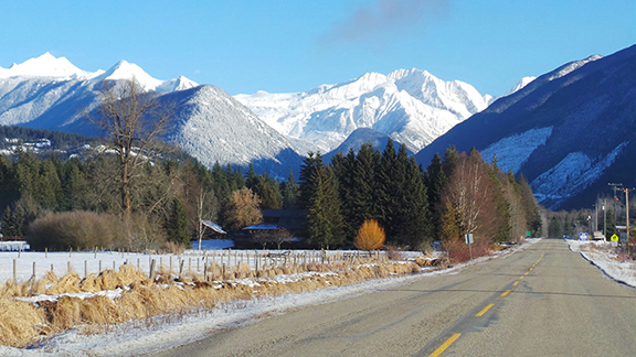
North End of Kootenay Lake Forty km (25 miles) north of Kaslo is the beautiful Lardeau Valley which embraces the small communities of Lardeau, Cooper Creek and Meadow Creek, Howser, Argenta and Johnsons Landing. The rich valley bottom farmland is the result of the ebb and flow over thousands of years by the Duncan and Lardeau Rivers through the flats at the head of the lake.
The area was first settled at the turn of the last century when a flood of prospectors searching for rich lodes of ore invaded the area. In 1912, the first of several homesteading families arrived to eke out a living by farming and logging on the bench land. Starting in the 1950s the area saw an increase of people who were looking for a way to build a principled and sustainable community or just to get back to nature.
The north end of the lake includes five biogeoclimatic zones, from low-lying wet valleys with towering cedar and cottonwoods to the scree on the peaks dribbling down into spectacular alpine meadows. Wildlife includes deer, moose, elk, black and grizzly bears, mountain caribou, wolverine, wolves and mountain goats. More than 68 species of birds have been recorded. Some of the streams contain native stock of cutthroat and rainbow trout, Dolly Varden (bull trout) and mountain whitefish.
Meadow Creek Spawning Channel The spawning channel is open to the public for the duration of the spawning season, unless there is unusually high bear activity. Walkways and an interpretive site allow visitors the opportunity to learn about this wonder of nature. It is located 4 km north of Meadow Creek off Highway 31. The gate is open from 10am-2pm, daily, from late August to early October. If gate is closed, there is no access that day (please respect as this is usually due to high bear activity and is for your own safety).
Duncan Dam Kootenay Lake was dammed in 1967. The Duncan Dam, a 40 metre earthfill dam with no power generation facilities, was the first of the three Columbia River Treaty dams to be built in the Canadian section of the Columbia River Basin. It was designed to control the flow of water from the Duncan River into Kootenay Lake. The Duncan is the tributary that provides about 13% of the water flowing into Kootenay Lake.
As the dam neared completion, the valley bottom was cleared of large trees, the original residents of the community of Howser displaced, and some farms and orchards were flooded. When the water began to rise and fill the new reservoir, the original Duncan Lake increased in size from 25 km to 45 km in length.
You can visit the dam. Follow the signs on Highway 31 north of Meadow Creek to Duncan Dam.
Water in the Duncan Lake reservoir fluctuates seasonally by as much as 30 metres in elevation. When the water is low in winter and early spring, you can still see traces of the prior settlement and the ghostly stumps of the trees. Operations of the dam can cause fluctuations in water levels downstream, at the north end of Kootenay Lake. This is an attractive area for canoeing, but care must be taken because of the potential for sudden flooding. For reservoir information call 1-877-924-2444.
See where to eat , sleep , play and shop in town. Also, visit www.gokootenays.com to learn more about the surrounding Kootenay areas.


